Why was this study undertaken?
Following a large magnitude flood event in February 2021 it was noted that the course of the River Dee had changed, most notably in the vicinity of Ballater Golf Course. RPS were commissioned to undertake an Additional Flood Study, to identify any changes to flood risk resulting from significant morphological changes to the River Dee, and to assess the potential for minor works to manage any increased flood risk to Ballater.
What additional surveys were undertaken to update the previous model?
The 2018 hydraulic model was updated using newly surveyed channel cross-sections, extending from the northern end of the Golf Course at the Old Line Road to the Royal Bridge and supplemented with new high-resolution LiDAR of the left bank of the River Dee in the vicinity of Ballater Golf Course. The new survey was completed between March and April 2022 and as such captured channel and floodplain changes to the River Dee at Ballater that have occurred since 2018. The updated model was used to simulate the range of return periods as in the previous study, with a comparative analysis of the 2018 and 2022 studies being undertaken.
Has the flood risk in Ballater changed?
Comparative analysis of the 2018 and 2022 studies revealed a significant increase to flood extents in the 50, 20, 10 and 3.33% AEP events, with minor differences noted between the lower-frequency, higher-magnitude events of 1% AEP and greater. Particularly evident are increases in the extents generated by 50, 20, 10 and 3.33% AEP events, where increases are notable on the left bank floodplain in the vicinity of Ballater Golf Course. Concurrently, decreased extents are noted on the right bank upstream of Royal Bridge and on the right bank upstream of the Red Braes.
Given the dynamic and high-energy nature of the River Dee, it is important to note that the flood extents and associated risk as identified by this Study are derived from the representation of the river channel and floodplain at the time of survey (March to April 2022), and it is entirely possible that any further geomorphological changes to the channel could alter the modelled extents again.
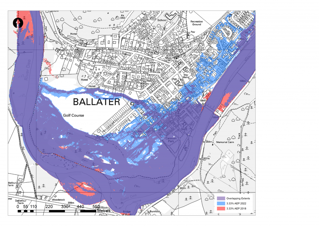
The figure below compares the flood extents for a 3.33% AEP event from the updated 2022 model compared to the Flood Protection Study 2018 model. 2018 extents are shown in red and 2022 extents in blue, with areas of overlap between the two periods shown in purple. Results of the modelling from the 2018 study determined that in a 3.33% AEP flood event, 204 properties in Ballater could be at risk of flooding. In the 2022 simulations of the 3.33% AEP flood event, an additional 195 properties are shown at risk of flooding, taking the total number of properties at risk to 399.

2018 vs. 2022 3.33% AEP flood extents
What is meant by AEP?
Flood event probabilities are referred to in terms of a percentage Annual Exceedance Probability (AEP). This represents the probability of an event of this, or greater, severity occurring in any given year. They are also commonly referred to in terms of a Return Period which is the time, typically in years, in which we would expect an event of a certain magnitude to occur. This period is not the length of time that will elapse between two such events occurring, as, although unlikely, two very severe events may occur within a short space of time. For this reason, ‘AEP’ is more frequently used now rather than ‘return period’. The table below sets out the range of flood event probabilities for which the updated model was run, expressed in terms of Annual Exceedance Probability (AEP), and Return Period. It is easy to convert return period into AEP by dividing into 100, and vice versa.
| Annual Exceedance Probability (AEP) | Return Period (Years) |
| 50% | 2 |
| 20% | 5 |
| 10% | 10 |
| 3.33% | 30 |
| 1% | 100 |
| 0.5% | 200 |
What minor works options were considered?
Minor works were suggested by members of the local community, and these were further investigated as part of the Study using the updated model. The following options were investigated:
- Removal of dead trees from river channel and reuse in bank reinforcement.
- Clearance of deposited gravel from main river channel on Glenmuick side.
- Clearance of outlet channel for watercourse across Golf Course.
- Build new bund across rough ground at southern end of Golf Course.
- Combined Options 1, 3 and 4.
- Build new bund to north of Golf Course.
- Clearance of outlet channel at Golf Course and build a new bund to south of Golf Course.
What is the preferred option?
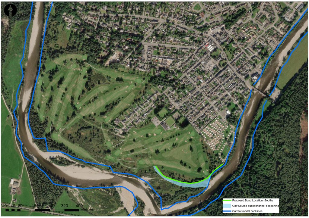
Option 7 showed the most significant reduction in flood extents impacting receptors in Ballater of all of the modelled options. The figure below shows the location of the proposed works which include deepening of a 330m reach of the Golf Course outlet channel by 0.5m in conjunction with a 440m long, 1.5m high bund on the left bank.

Option 7 South bund & clearance of outlet channel
What protection does this option provide?
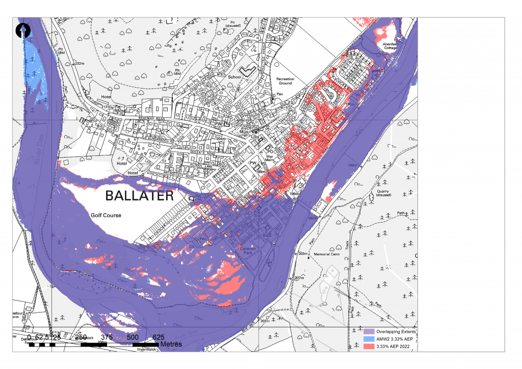
The flood extents from Option 7 are shown in the figure below, along with the 2022 baseline. Note that the new baseline flood extents from the 2022 study are shown in red, the extents from Option 7 are shown in blue, and any areas where the flood extents overlap are shown in purple. In a 3.33% AEP flood event, this option can reduce the number of flooded properties from 399 to 249. The properties that will now be protected are located within the area shown in red, while the properties shown in purple will still be at flood risk.
In its current configuration Option 7 offers the best opportunity to offer protection to at-risk properties for flood events of the considered magnitude/ return periods whilst also not exacerbating or contributing to the severity of flood risk likely to exist in larger magnitude/ lower frequency events. Option 7 is therefore the preferred option to meet the objective of the Ballater Additional Flood Study, which was to assess the potential for minor works to manage the flood risk to Ballater until such time that a decision is made to implement the proposed main scheme. Note that the proposed main scheme will provide protection to all properties up to a 0.5% AEP event.

Option 7 3.33% AEP flood extent
Could the remaining properties at risk be protected by Property Level Protection?
Aberdeenshire Council asked RPS to consider how many properties which remain at risk of flooding in a 3.33% AEP event following the construction of Option 7 could benefit from the use of Property level protection (PLP), which is the installation and deployment of a range of flood resistance and flood resilience measures. PLP can provide communities in flood risk areas with flood measures that are cost-effective and easy to operate, however it does rely on timely installation of the products and requires long-term storage and maintenance of the products. The use of PLP depends on flood warning, which is provided by SEPA and the Met Office through the Scottish Flood Forecasting Service. PLP would typically provide protection against flooding for depths of up to 0.6m. There are 204 properties identified as being at risk in a 3.33% AEP event that may benefit from PLP. That leaves 45 properties that PLP would not be suitable for. Note that a survey of properties has not been completed to identify whether or not PLP would be suitable. Aberdeenshire Council retains a stock of a small selection of these products and is willing to sell them to the public at cost price. Further details can be found on the Aberdeenshire Council website:
https://www.aberdeenshire.gov.uk/environment/flooding/flood-protection-products/